If the North Downs are the wall around the south of London, then the Greensand Ridge is its advanced line of defence. This largely tree-topped ridge of greenish-coloured 'lower greensand' sandstone runs roughly parallel to the Downs and a few kilometres to the south. It's part of the geography of the Weald dome rather than the London basin, though of course the geological structures are continuous. The greensand dates from the Aptian stage of the early Cretaceous period, some 125-112 million years ago, and, like chalk, is associated with life and seas rich in organic deposits. The chalk came later, a vast continuous sheet of it, and north of here it became indented to form the London basin, while south of London earth movements ab0ut 30 million years ago pushed layers of chalk and greensand up into a dome. Erosion did the rest, slicing through the chalk at the top of the dome to expose the underlying rock layers, leaving exposed chalk as ridges round the edge -- today's North Downs and South Downs -- with the greensand layer below the chalk now also exposed as a second ridge.
That ridge marks the furthest edge to which the London Countryway ventures, and it dominates today's walk, much of which is through what the Kent Downs Area of Outstanding Natural Beauty identifies as the "Sevenoaks Greensand Ridge". According to the AONB. its key landscape characteristics are "extensive mixed woodlands, heathy commons, small orchards and pastures, magnificent views, lines of mature trees, ragstone buildings", all of which I'll see today. The magnificent views are southwards towards the High Weald, part of which also forms a separate AONB, where more hills, of earlier Wealden sands, push up from the broken centre of the dome. Last week, leaving the Downs, I started to feel I was straying too far, with the gravitational pull of London weakening. Today, I'm reassured that we've reached the outer limit of this part of our journey -- Keith Chesterton, who devised the route, keeps it clinging to the ridge, gazing at but not venturing into the Weald proper, and I'll end today's walk in a major commuter town.
Also characterising today's walk is a series of historic buildings and estates, most of which are wholly or partially open to the public, the sort of property often known by the now rather quaint and old-fashioned term "stately home". In one sense these places are an historical category, substantial civilian residential properties dominating country estates of the post-feudal period, from the days when the Lord of the Manor no longer exercised manorial rights over the local tenants but dominated through economic means instead. But they're also part of the mythology of rural England, symbols of continuity and tradition rooted in the mediaeval past. This mythologising was already at work when "morally improving" poet Felicia Hemans (1793-1835, most famous line "The boy stood on the burning deck") first coined the term in her 1827 poem 'The homes of England':
The stately homes of England,
How beautiful they stand,
Amidst their tall ancestral trees,
O’er all the pleasant land!
Noël Coward (1899-1973) famously parodied this stanza 110 years later by replacing the final two lines with "To prove the upper classes / still have the upper hand." Coward was both wrong and right. A minority class did indeed still have the upper hand in 1937, as indeed today, and some of the descendants of those who built the stately homes of England still have significant property-owning might -- today, 70% of land in Britain is owned by 1% of the population, including massive holdings by the likes of the duchies of Norfolk and Lancaster. The ideology of Englishness and English tradition to which the myth of stately homes contributes has long benefitted the property-owning minority. But the economic framework in which these buildings were developed was changing irrevocably even when Hemans penned her doggerel, with the country estate as self-contained economic unit outstripped by the massively enhanced profitability and productivity of large-scale industry. As the 20th century progressed, the old estates became unsustainable, and those that survived found a new rôle in the growing industries of leisure and tourism, destinations for day trips and heritage tours. And while there's something pleasingly democratic about oi polloi thronging tapestry-hung corridors and oak panelled libraries that were once the preserve of the privileged and their servants, the cultural baggage accreting in the space evacuated by economic function is more likely than not to tell a false story of British identity.
If there is an organisation firmly associated with the stately home it is the National Trust: the two together conjure an image of genteel days out gawping at roped-off heritage under the tutelage of elderly women with cut glass accents, and admiring the view of the formal gardens over a cream tea in the orangery café. But the image turns out to be rather unfair, and increasingly unwelcome. As its full title, the National Trust for Places of Historic Interest or Natural Beauty, indicates, it is not entirely concerned with the built environment, and when founded in 1895 it was at least as much concerned with saving threatened green space from development and opening it up for public use. It came at the culmination of a series of 19th century campaigns aimed at saving green space and securing countryside access, supported by middle class philanthropists convinced of the benefits of access to the outdoors for working people, particularly those otherwise forced to suffer the unhealthy conditions of industrial towns. Its most famous founder, Octavia Hill (1838–1912), was involved in many such campaigns including for modest urban parks like Honor Oak Park in Lewisham. We'll come across the legacy of numerous struggles of this kind on our walks.
The Trust is today one of Britain's single biggest landowners, with 2,520 km², about 1.5% of the total land mass of England, Wales and Northern Ireland (Scotland has its own, separate, organisation). Most of this is parkland and countryside, open to the public free of charge, including substantial holdings around London, and its oak leaf logo will become increasingly familiar as we proceed. It's also keen to point out that its buildings aren't just stuffy old houses -- in fact our first encounter with that logo was back at Coldrum Longbarrow, from a very different period of architecture, and its more famous recent acquisitions include John Lennon's childhood home in Liverpool. Nevertheless the Trust is now much more of an establishment institution than its combative roots might once have suggested, enjoying a unique position as a British NGO in having its powers defined by specific statutes and able to issue its own by-laws. It's the stately homes that rake in the bulk of the cash from its predominantly middle England supporter base, and the debate over the hunting ban very nearly tore it apart.
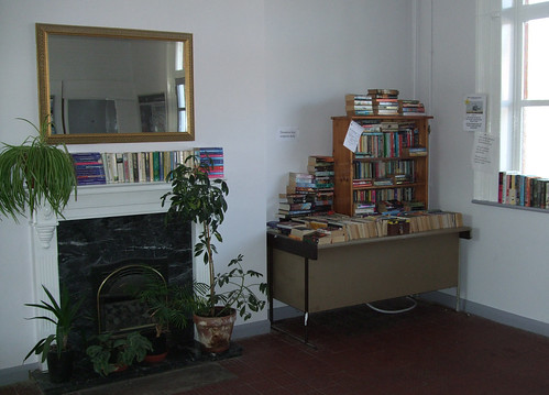
Arriving again at Borough Green station, I leave through the ticket office, which hosts a charity book sale in aid of the Air Ambulance. Alongside the bookcases, someone has added tables and potplants, given the place the appearance of a living room -- it's a shame no-one's selling pots of tea.
I leave "businesslike" Borough Green and reach the cluster of farm signs in Crouch Lane again, keen to solve a puzzle raised by the 1981 London Countryway guide. This appears to show the route following the farm track from here to Basted, but this doesn't appear as a right of way on the map. A man working in the fields tells me the latest map is right -- the farm track is blocked off further down, and the bridleway runs by a different route, initially through the hedgerow parallel to the lane.
This turns out to be an attractive and well-defined route that soon leaves the lane and heads off through rich woodlands, emerging by what back in the early 18th century was a water-powered paper mill, one of a series along the river Bourne, a tributary of the Medway that rises not far away in Ightam. The mill was later converted to steam power and finally closed after flooding in 1968, after which the site was taken over by the legal and accountancy specialist publishers Butterworths, now part of the huge Reed-Elsevier group. They left in 1997 and the mill has been redeveloped as housing, which takes advantage of the attractive waterside setting and surrounding green space -- some of the water features have been preserved or reconstructed, such as the mill pond and a waterfall -- but attempts by the architects to parody local vernacular styles give it a slight Disneyland whiff.
I note from a sign that the road through Basted is a designated Quiet Lane --it turns out to be part of one of the earliest demonstration projects of this initiative in England, launched in 2001. The idea, originating in Guernsey where such lanes are known evocatively as ruelles tranquilles, is to encourage more walking, cycling and horseriding on certain country lanes, balancing use more evenly with motor vehicles, by such measures as resigning the road network to discourage through traffic along them, reducing signing sizes and getting rid of clutter and other road markings to create an environment that is less obviously driver-friendly. I'm very much supportive of the intention -- in my view, walkers' organisations gave up the roads rather too easily to drivers in the last century, leaving the tarmac a no-go area of high speeds and selfishness by opting instead to stick to footpaths wherever possible, thus reinforcing the view that roads are primarily for drivers.
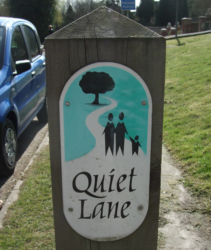
In fact, both legally and morally they are not -- except on motorways and some other purpose-built fast roads, walkers have just as much right to use the roads as drivers, indeed more so as their use is less regulated. The surfaced road network developed over an existing network of mainly unsurfaced paths and tracks, and unsurprisingly it was usually the most direct and convenient routes that were chosen as modern roads while the back ways were left as footpaths. So while it's fine for a leisure walker to stroll idly along the scenic route, for local everyday trips the road is usually the obvious route, and if people don't feel safe there, they'll simply use their cars, further feeding the vicious cycle of car dependency. And except for the traffic, roads are more accessible than most paths, with unobstructed flat surfaces that can also be used by wheelchairs and pushchairs. Other countries are much better at managing walkers and cyclists on rural roads than we are in the UK. Unfortunately I'm not sure that a bit of sign tweaking is going to do the trick without the support of speed limits, enforcement and physical measures like humps and narrowing, and sadly the Quiet Lanes project seems to have been forgotten about recently, perhaps for lack of an effective advocate.
Only a short distance along the quiet lane I fork right along a "restricted byway" -- another legacy of the rather curious development of English highway legislation, which works on the principle of "once a highway, always a highway" and also derives much of the law governing motor vehicles from that governing their horse-drawn predecessors. Byways, alongside another miscellaneous category of route known as "Roads Used as Public Paths" (RUPPs), are old roads that for various reasons didn't end up being maintained as part of the modern surfaced road network, but may at some stage have been used by horse-drawn vehicles, so may be legally usable by car drivers. Most are physically inaccessible to conventional road vehicles but the growing popularity of off-road vehicles like 4x4s and trials bikes has put them under unforeseen pressure, with some churned into rivers of mud. Restricted byways are a recent legal invention to deal with this problem, being open to horse-drawn carriages but not horseless ones, and most RUPPs have now been reclassified accordingly.
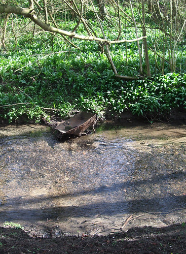
The broad muddy track -- a little churned up recently by contractors' vehicles on tree maintenance duty but easily passable -- is our first riverside footpath since leaving the Thames: the Bourne is little more than a stream but it's pleasant to be beside the water, and the odd piece of inadvertant public art such as a half-submerged and decaying wheelbarrow adds to the interest.
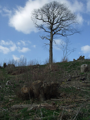
Leaving the waterside, the route heads across a recognisable orchard with dwarf but otherwise unrestricted trees, unlike the science fiction version we crossed last week, although a sign warning the trees have been sprayed is unsettling. Kent used to be one of the most important counties for orchards, growing not only apples and pears but cherries and cobnuts, though 85% have gone over the past 5o years.
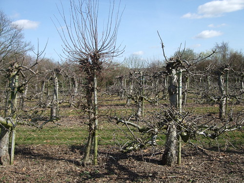
We're now in the most substantial cluster of them we'll find on our walk through Kent, and more of them stretch uphill to the right of the route as it continues down a good farm track, with views across the Weald beginning to open up on the other side.
A constant stream of walkers is coming towards me, all grasping the same printed handouts. They turn out to be participants on the Sevenoaks Circular Walk, a challenge event organised by the Kent group of the Long Distance Walkers Association (LDWA), which starts from the Vines in Sevenoaks and has a choice of routes from 22.5km (14 miles) to 48km (30 miles) to be completed in 10 or 8 hours. These big walking challenges puzzle me -- I'm a lone walker usually fighting the urge to challenge myself and forgetting to enjoy myself -- but they've certainly been lucky with the weather, which is beautifully sunny. I later discover about 300 people have participated, but even without this bulk upload, the paths are busy with others out on foot.
After the intriguingly named hamlet of Yopps Green, just north of Plaxtol, there are more orchards and a woodland strip, and we pass just to the north of the first of our big country houses, and the only one completely closed to the public: Fairlawne (or Fairlawn), once the estate of politician and royalist-turned-parliamentarian Henry Vane (1589-1655), whose son, also Henry (1613-62), became governor of Massachusetts. Reaching the first main road of the day, the A227 Ightham Road, which we last encountered leaving Gravesend where it crosses the A2. Ightham (pronounced "eye-tem"), to the north, is now bypassed -- the village dates back to Saxon times and name probably comes from a Jutish personal name. On the other side a sign welcomes us to the Fairlawne estate, initially on a woodland path, but suddenly the vegetation changes to a more heath-like environment, with gorse and rough shrubs. It doesn't last, and we're soon heading downhill on a field edge, with wide views in front, past stands of Scots pines. I've already started to notice waymarks revealing we're in National Trust territory, staking out circular walks on the Ightham Mote estate.
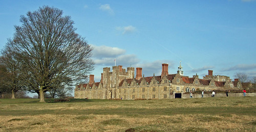
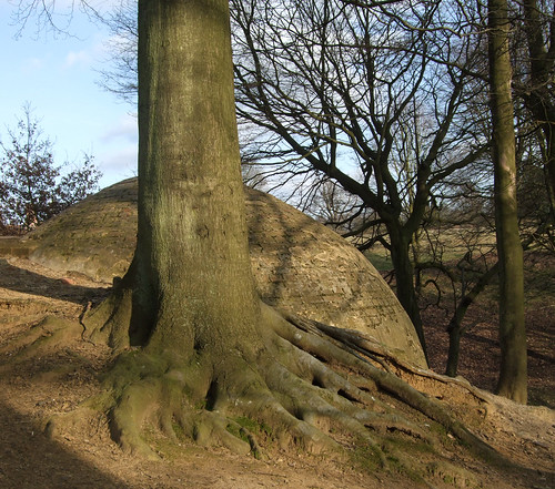
At the bottom of the hill the route turns east down a lovely walled track, past some photogenic oast houses and to Ightham Mote itself, also doing great business on this fine day. It's one of the best surviving examples of a moated mediaeval manor house, with quite a bit added in Tudor times, a pleasant prospect of half-timbering, warm ragstone masonry, ponderous chimneys and a complete moat. When Chesterton wrote his guide it was still in private hands, but in 1989 it came into the hands of the Trust and it's proved their biggest conservation project ever.
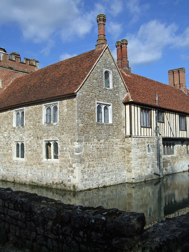
As we'll see, it's a notable contrast to the other major Trust property on today's walk, Knole -- that is a massive house commanding vast parkland, all about display, but Ightham Mote is not only more intimate, it's also clearly preserved traces of its role as the nucleus of an economic unit, a working mediaeval agricultural estate. Its 221 hectares of rolling fields and meadows were hardly changed until the 19th century, and some has been restored, so walking these paths is nigh-on the closest you'll get to experiencing a two-centuries-past-Domesday landscape. Not so long ago, estates like this could be found on the edges of the City and Westminster, which here seem a very long way away.
Reaching the lane just by the house, we reenter the Kent Downs AONB and join the Greensand Way, the second of the major long distance paths that the London Countryway shares some of its alignment with. In fact the Countryway wasn't fully established when Chesterton wrote his guide -- but the way west, following the greensand ridge, is obvious so it's not surprising they share foot space for some time to come. The path passes through the estate's still working home farm and keeps ahead as a fine track on the edge of the ridge, with trees hanging to the steep slopes above and right, and occasional clusters of greensand boulders strewn on the surface.
Soon after leaving the farm we've crossed the boundary from Tonbridge & Malling borough into Sevenoaks District, but we cross and recross for a while as the boundary meanders across the ridge independently of our path.
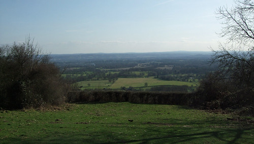
Now definitively in Sevenoaks (the District, not the Town), I'm soon in another National Trust property, One Tree Hill, originally purchased for the Trust in 1911 in memory of Octavia Hill's half brother Arthur Hill -- the first tranche of Trust-owned countryside sans old houses we've encountered so far. At the 207m summit a clearing reveals a spectacular view that just demands to be drunk, with the craggy High Weald rising up in the distance over the Eden valley. Chesterton wrote that this section is in his opinion the most beautiful on the walk, mainly for its distinctive views, and standing here it's easy to see why.
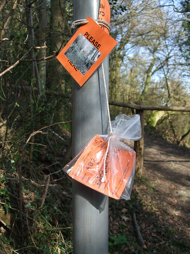
Leaving the hill I spot some checkpoint cards for a Duke of Edinburgh Award event taped to a post in plastic bags. I hope the participants appreciated the views -- the young people I've seen on these events in the past always look so glum.
Beyond One Tree Hill we pick up another track hugging the contour of the ridge, before the landscape plateaus out in a field where roped off horse paddocks annoyingly disrupt the line of the right of way. A damp woodland path brings us out opposite a very serious-minded metal gate, through which we're in a different world -- the scrubby wooded parkland and well-used broad avenues of the self-consciously splendid Knole Park estate. The Greensand Way and Countryway only skim the southern edge of this vast 4km2 park, running down the obviously named Chestnut Walk, but here I have a decision to make.
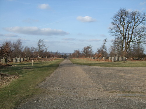
The break point for this section is not straightforward. Keith Chesterton chooses to end the section at Ide Hill, but public transport was sparse there even back in 1981 and the situation hasn't improved since, with the occasional bus on weekdays only. I'd quite like to see more of Knole Park and end in a sizeable town, especially one with an excellent rail service, so I decide to head north to Sevenoaks, but not before I've pursued the Countryway a little way further to another potential break point, on the main Tonbridge Road to the west of the park. This section of road of between Sevenoaks and Tonbridge was in 1710 the first turnpike road in Kent. In the 1920s it was designated as part of the A21, the major trunk road from London to Hastings, which begins just a couple of kilometres south of my home at the roundabout by Lewisham station. A major bypass was constructed in 1966, and the old road redesignated A225, but it's still busy enough with traffic, much of it driving far too fast round the series of sharp bends through which the road snakes rapidly down the Greensand ridge. The buses aren't straightforward even here, however -- while on weekdays they run regularly down the main road from Sevenoaks station, stopping just short of the junction with the lane that takes us into the park, at weekends they run hourly and are diverted via Sevenoaks Weald, with the nearest stops being at the bottom of the hill where the old road has a junction with the bypass.
This short stretch of road southwest of the park shares its name, Riverhill, with another country house, at core a Queen Anne mansion on the site of a Tudor farmstead, built of ragstone quarried from the ridge on which it sits, though much altered and expanded. The entrance is immediately opposite the footpath on the opposite side of the road along which our route will continue. It's particularly noted for its gardens, established in the 1840s when John Rogers, a keen horticulturalist and plant collector, bought the house. It's still in Rogers' family, and they open the gardens to the public on Sundays and weekend bank holidays during spring.
Heading back to Knole Park, I strike up a good pace along another broad avenue -- Broad Walk -- before following a helpful series of waymark posts across more undulating ground and scatterings of trees, in the company of crowds of Sunday strollers. I note there are no Greensand Way waymarks in the park, even though this is part of an official Greensand link route to Sevenoaks and the Darent valley -- presumably the estate managers are pernickety about such things.
I'm soon following the wall that separates the house from the park, and begins to give a feel for its massive scale of the place -- the house alone covers over 16,ooo m2 and reputedly has 52 staircases. Built by an Archbishop of Canterbury in the latter 15th century who left it to the See, it was later "requisitioned" from Thomas Cranmer by Henry VIII, and in 1586 came into the hands of the Sackville family. The family's most famous recent member, born in the house, was writer Vita Sackville-West (1892-1962), sometime lover of Bloomsbury writer Virginia Woolf. Sackville-West was the model for the androgynous hero of Woolf's novel Orlando, which is partially set in a fictionalised version of the park. A more recent bohemian connection is with the Beatles, whose seriously peculiar pioneering videos to 'Strawberry Fields Forever' and 'Penny Lane' were shot here in 1967. Sackville-West and Woolf loved the place, but John Evelyn found it depressing and, looking uphill at the vast edifice glowering over its deer park, I can see his point.
The Sackvilles still own the grounds and use parts of the house, but it's well used by the public, and an informal soccer game going on in the shadow of its walls cheers the place up. Back along the path, the distinctive igloo shape of an ice house nestles between the trees.
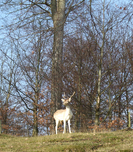
The grounds escaped reworking by 18th century landscape architects and still very much resemble their original form as a deer park, but I don't see any deer until quite near the exit, when I come upon a whole group of sika grazing unhurriedly by the driveway as the cars stream past. A young stag poses obligingly for me at the top of a hillock.
Leaving on the park, I pass the adjacent town council-run Sevenoaks Environment Park, which has tranquil woodlands threaded by inviting paths, but I'm now in a bit of a hurry. Sevenoaks originally grew because of presence of Knole but expanded hugely with the coming of the turnpike and still more when the railway arrived in 1868. Commuter services to London got faster when the line became one of the first to benefit from Southern Railway electrification in the 1930s, but the town keeps something of its own identity despite its umbilical links to the capital, with some interesting buildings and intriguing alleyways in the Y formed by its two main roads. According to the Town Council it's the "happiest" town in Britain, though I guess the fact that they've put quotes around "happiest" is indicative of the challenges of evaluation in this area. If you go looking for the oaks that allegedly give the town its name, the original group were in Knole Park but the official ones have been at the Vine cricket ground since 1902, although the Great Storm of 1987 put paid to the most of the oldest ones of these.
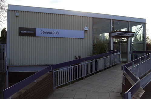
It's a long haul from the town centre to the station down Tubbs Hill into the Darent Valley, and the station buildings are a 1960s replacement of the Victorian original, oddly compact and modest for such a busy place.
Here the Greensand link ends and the Darent Valley Path begins, heading up via the North Downs towards the Thames at Dartford -- entirely outside London but entirely within the Countryway, it qualifies for London Underfoot status -- but that's another walk for another day.
View a map http://maps.google.co.uk/maps/ms?ie=UTF8&hl=en&msa=0&msid=117966169375523396049.00046414d40d8252e7b70&ll=51.414197,0.368729&spn=0.106206,0.219727&t=h&z=12
Route description pdf
More information
- Kent County Council walking http://www.kent.gov.uk/leisure-and-culture/explore-kent/walking/
- Visit Kent http://www.visitkent.co.uk/
- Kent Geology (Kent RIGS) http://www.kentrigs.org.uk/kentgeo.html
- K-LIS (Kent Landscape Information System) http://www.kent.gov.uk/klis
- Greensand (Encyclopaedia Britannica) http://www.1911encyclopedia.org/Greensand
- Greensand (Wikipedia) http://en.wikipedia.org/wiki/Greensand
- Weald (Wikipedia) http://en.wikipedia.org/wiki/Weald
- High Weald AONB http://www.highweald.org/
- National Trust http://www.nationaltrust.org.uk/
- Tonbridge & Malling Borough Council http://www.tmbc.gov.uk/
- Visit Heart of Kent http://www.visitheartofkent.com/
- Maidstone East railway line (Wikipedia) http://en.wikipedia.org/wiki/Maidstone_East_Line
- Borough Green Parish Council http://www.boroughgreen.gov.uk/
- A25 (Wikipedia) http://en.wikipedia.org/wiki/A25_road
- Kent Downs AONB http://www.kentdowns.org.uk/
- Platt Parish Council (includes Basted) http://www.plattpc.kentparishes.gov.uk/
- Plaxtol Village http://www.plaxtol.com/
- River Bourne (Wikipedia) http://en.wikipedia.org/wiki/River_Bourne,_Kent
- Quiet Lanes http://www.naturalengland.org.uk/ourwork/enjoying/places/greenways/quiet_lanes
- Quiet Lanes (Rural Kent) http://www.ruralkent.org.uk/ourwork/rural-transport.htm
- Quiet Lanes (CPRE) http://www.cpre.org.uk/library/1888
- Orchards in Kent (England in Particular) http://www.england-in-particular.info/orchards/o-kent.html
- Kent LDWA http://www.kent-ldwa.fsnet.co.uk/
- Ightham Parish http://www.ightham.org/
- Ightham Mote (National Trust) http://www.nationaltrust.org.uk/ighthammote
- Sevenoaks District Council http://www.sevenoaks.gov.uk/
- Shipbourne Parish http://www.shipbourne.com/
- One Tree Hill (National Trust) http://www.nationaltrust.org.uk/main/w-global/w-localtoyou/w-south_east/w-south_east-countryside/w-south_east-places-north_kent/w-south_east-places-north_kent-oldbury_styants_one_tree.htm
- Knole (National Trust) http://www.nationaltrust.org.uk/knole
- Riverhill Gardens http://www.riverhillgardens.co.uk/
- A225 (Wikipedia) http://en.wikipedia.org/wiki/A225_road
- A21 (Wikipedia) http://en.wikipedia.org/wiki/A21_road
- Hildenborough Parish http://www.thisishildenborough.co.uk/
- Sevenoaks Town Council http://www.sevenoakstown.gov.uk/
- Sevenoaks Tourist Information http://www.sevenoakstown.gov.uk/Tic.asp
- South Eastern Main Line http://en.wikipedia.org/wiki/South_Eastern_Main_Line
- Darent Valley Path http://www.kent.gov.uk/leisure-and-culture/explore-kent/walking/darent-valley-path-walk.htm


1 comment:
"The Seven Oaks", (as recorded on the first Ordnance Survey,) are beside the first Turnpike Road in Kent, now the A21. They are about one mile south of the town centre on the ascent to Riverhill. The current set are replacements, their immediate predecessors were controversially removed to be used to make furniture under the false claim that they were diseased.
The Oak Trees on The Vine, planted in 1902 are the "Coronation Oaks" for obvious more recent historic reasons.
Post a Comment